
Trail Talkin’, about Scott Run Trail
In early December, 2018, CRF finished an upgrade of the ¼ mile of Scott Run Trail closest to McCollum Campground.
The short form summary of the Cooper’s Rock Foundation’s (CRF) upgrade to the ‘Campground Hill’ section of Scott Run Trail is: 60 tons of crusher run gravel were carefully placed, shaped, and compacted over a 1,300’ section of Scott Run Trail. Drainage improvements were made throughout this southernmost section of the trail. Now that we’ve completed our upgrade of this trail segment, the trail is dry, and is much more appealing to Walkers, Runners, Mountain Bikers, and Cross-Country Skiers than it used to be.
When you spend a lot of time on a project, though, you tend to think about it, in depth, incessantly, and maybe even to a point approaching obsession. If you are a certified trail nerd, like I am, then you may want to read the long form that follows, the more detailed summary wherein I get some of those trail ruminations down on paper. Not a lot of trailworkers write about their trail craft, so I hope this interests you. Here, I’ll go into depth about the challenges we faced when we undertook this upgrade of one of Coopers Rock’s worst sections of trail, how we solved the problems, and who we hope benefits from the now-completed work. Not only did we place new gravel upon old gravel, we overlaid an old roadbed perhaps from as far back as the 19th century, with 21st century sensibilities and considerations for an array of user groups and technical levels.
Before we go any farther, you need to understand just how crappy this section of trail really was – the reason why we did all this work. And I did choose that adjective after some consideration, because there’s no way around it, that section of trail was downright crappy! I ranked this ¼ mile of Scott Run Trail in The Bottom Five of worst trail segments at Coopers Rock. For reference, the other end of this trail, the ¼ mile closest to the Interstate Exit, is the #1 worst segment of Coopers Rock trail of all (and is on our list for 2019). Translation: Really lousy !!
For decades, the majority of this ¼ mile of trail – ‘Campground Hill’ — seemed to be perpetually soaking wet and running with water for hundreds of feet at a time. Groundwater springs surfaced next to the trail and flooded it. Rainwater accumulated on the trail and ran down it, unabated for hundreds of feet. The entire surface of the trail segment was coarse, rounded cobble, frequently loose. It was far below standard for many users of the trail, regardless of season. Some regular trail users have been avoiding the trail altogether for years because of its condition. Did anybody at all like it as it was? Yes, there is a breed of trail runner who wants every run to be like running a “mudder” race – with lots of obstacles like logs, rocks, streams and more. There’s a share of mountain bikers out there who will rue the loss of this ‘downhill field of soaking wet baby heads’. While there’s a place for mudders and babyhead fields in this world, it is not on a multiple-use, popular trail that should be a Signature Trail of this West Virginia State Forest. Both groups should understand that wet, loose cobblestones are not the preferred trail surface for most people, and that the small loss of that to just a select group is a worthy trade-off for the large gain for the vast majority of trail users.
To remedy all problems, the loose, coarse surface had to be made finer and smoother, and all drainage problems had to be dried up as well. There are a few key points to understand about how we fixed this mess, and why we chose our methods.
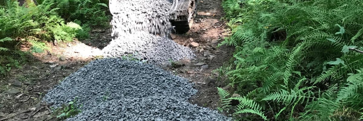
The first point to know about this trailwork situation is that this project was all about rock. Not dirt, but rock. Most Coopers Rock trails are made of dirt, but not this one. The entire segment of Scott Run Trail we worked on was an old road, made by whom and exactly when, I do not know for sure. Maybe the CCC, maybe the McCollum Sisters, maybe a 19th Century logging company, possibly even the iron industry…? It’s covered with what appears to be old, coarse, compacted gravel made out of the rock type native to the site, sandstone. This old coarse gravel might have been made on-site by workers with sledgehammers, or some diesel hammering machine, many decades ago. There is plenty of dirt on either side of the trail, as this trail runs through the forest, but the trail itself has virtually no soil on it. We added new, finer-grained rock on top of that old rock. We used 60 tons of ¾” crusher run gravel along 1,300’ of trail.
The second thing to know is that not all gravel is the same. This a crucial point! Gravel comes in a surprisingly wide spectrum of sizes, rock types, and shapes. ‘Typical’ gravel is known as “57s”, and this is the grey, limestone gravel you see on just about any gravel driveway. Every grain (or pebble or rock or stone) of 57s is about the same size, which is between 1” and 2”. This type of gravel is made (at quarries, with stone-cutting machinery), by design, to always have pore spaces between the grains, for drainage purposes, as water will drain through this gravel. When all the grains are about the same size and shape, there will always be pore spaces between the grains. Crusher run gravel, on the other hand, is the opposite of 57s. Crusher run gravel contains a spectrum of grain sizes instead of just one size, which in this case run from ¾” down to coarse sand. With crusher run gravel, you get the opposite effect of 57s – the smaller grains fit inside the pore spaces between the larger grains, and it all compacts tightly together, so that there are no pore spaces between the grains. Our crusher run topcoat is both tightly compacted and also has a prominent crown (convex shape) on top, so water runs off the sides of it instead of draining down through it. If 57s had been used on the trail, you’d have a crunchy, unstable surface underfoot or under-tire, and you’d be plowing through it instead of rolling or running over it. And you’d hate me!! 57s gravel does NOT provide a recreation-friendly surface!! With the use of crusher run gravel, on the other hand, you get a stable, hardpacked, recreation-friendly surface that stays dry and lasts for a long time.
Now that we’ve talked rocks and gravel, it’s time to introduce The Rule Of Eight. This rule encompasses my approach of considering the perspectives of all trail uses that are legal at Coopers Rock – (1) walking/hiking, (2) running, (3) mountain biking, and (4) cross-country skiing. Are the trail perspectives of these activities really that different from one another? Consider the different experiences you would have driving on the Main Road at Coopers Rock if you were *riding a motorcycle, *driving a pickup truck towing a trailer, or *driving an 18-wheeler, as compared to *the car you typically drive on that road. It may be the same road each time, but the experience, the set of considerations, and the perspective from the driver’s seat, are different for the operation of each of those motor vehicles. Likewise, to some degree, there is a difference in how a trail is perceived by each of those aforementioned recreational user groups. When keeping The Rule Of Eight in mind, one considers the trail goals of keeping trails dry, clear, and well-marked, through the lens of this Rule, for these four uses, in both directions – four times two equals eight.
Perhaps the most important application of this Rule Of Eight approach falls under the ‘keeping trails dry’ goal, and thus how we shape drainage features on the trail bed. If a trail were only for foot travel, drainage features like dips and water bars could be shaped like a gutter along the edge of a roof (which has square corners), or a simple, steep-walled trough. But to accommodate ski and bike traffic, steep, abruptly-shaped drainage features are a no-go. Instead, rounded, gently-angled drainage features are needed, to accommodate these other uses. The best way to understand the difference is to experience it, but short of skiing it or biking it yourself, know that we seek to avoid the poorly designed drainage feature that interrupts the downhill run of a cross-country skier, or the uphill climb of the mountain biker, for two key examples.
Further, this ‘Campground Hill’ trail segment has had lots of drainage issues over time, so all water running down the trail had to be accounted for, so that it crossed the trailbed and went over the hillside, instead of running down the trail and creating a small-scale whitewater river after every single rainstorm.
Now you know about the trail’s former condition, about gravel, and about The Rule Of Eight.
So, our biggest challenges came to be twofold:
*accounting for every bit of drainage, and
*transporting all the crusher run gravel.
Managing drainage on a hillside trail is like managing drainage on your house. It doesn’t matter what else you do to keep your house dry if your roof is leaking, so you start at the top of your house – the roof — to eliminate leaks there, and work your way down. We followed that same principle on Scott Run Trail. The uppermost drainage ditch of all that we dug on the entire project is just uphill from the southern terminus of the trail, in the open field next to the entrance to McCollum Campground. This is the top end – or peak of the roof — of the trail’s own watershed. It took a backhoe to dig this 300’ long ditch. Another ditch nearby was also dug with a backhoe. Those two huge drainage ditches, coupled with a handful of smaller ones, took care of all the water problems in the upper section – ‘the roof and upper stories’, so to speak — of this 1,300’ long jobsite. Then, on down the trail, other drainage issues, in the form of both surface water, and ground water leaking out onto the trail, were inventoried during and right after rain events, and marked with flags. We dealt with these by digging drainage ditches, dips, and water bars. Wherever these features crossed over the trailbed, we carefully shaped them. We revisited our drainage work several times over two years as the overall project progressed. It wasn’t until early December 2018, that we finished shaping all of them to comply with the Rule Of Eight. Only then did we finalize the shapes and angles of the water bars and dips in the trailbed. *If you rode it before then but not since we finished it, go back and feel the difference.*
The big decision on this project, other than how to solve all the drainage issues, was to use ¾” crusher run throughout the entire problem-ridden zone, compacted, to form a smoother, drier trail bed than what has been there for many decades. It so happens that the old road that this trail is based on is much wider than a typical single-track trail in places. Since any environmental impact caused in constructing this old road happened long ago, I decided that, since it’s already there, our upgrade should maximize the recreational opportunity and put the entire width of the corridor to use.
But it costs time, effort and money to move gravel by the ton, on steep terrain. Did the entire width of the old road bed need to be top-coated with compacted crusher run? That’s a lot of square footage to cover. The answer ended up being no, the entire width did not need to be top-coated. I settled on the width of 42” for the width of a 1,300’ ‘easy’ lane, on the uphill side of the trail, with that lane seamlessly integrated into the rest of the trailbed width, whether it be an extra foot wide or an extra eight feet. That extra portion of trail was also worked upon and improved, but not top-coated.
The side-by-side strategy is like having a groomed Blue run at a ski area immediately adjacent to a Blue-level mogul field, a 5.4 rock climb with some optional, parallel 5.6 sections, or a Class II whitewater run with some optional, adjacent rapids that you can choose to run, or avoid, at a level of Class III. The two side-by-side designs give you adjacent, contrasting choices in either direction.
Before moving crusher run onto the trail, I chose and marked a center line for the 1,300’ section, using field-marking paint that fades within weeks of application. Then a pair of lines parallel to that enter line were painted to make a 42” wide lane. Then all the loose cobble from outside that 42” lane was collected by hand and a spine of rocks laid along the center line. This cobble spine would help form the crown, once the crusher run was brought in.
To move gravel down to the upper half of this project, we primarily used bucket brigades formed of large volunteer groups. 30 students, 50 five-gallon buckets, some shovels up at the pile in the parking lot and some rakes down at the ‘working edge’ of the project, and we got pretty far. With the help of a few different groups (we’re eternally in your debt for your hard work!) we moved close to 30 tons of crusher run from the Reservoir Parking Lot down onto Scott Run Trail without the use of machines. But such work takes its toll on any worker sooner or later, and the farther you have to go from the source pile, you either need more volunteers, or those you do have must work harder and harder to get the gravel to the working edge, which is continually moving farther, farther, farther away from the source pile.
Our uses of the bucket brigade tactic proved two things. It demonstrated that a well-organized, sufficiently-staffed, motivated bucket brigade can really move mountains – it was a very appropriate tactic — up to a certain point. And that is the other point clearly proven – there’s a tipping point, and once you cross it, it then makes sense to turn to the world of machinery for some help.
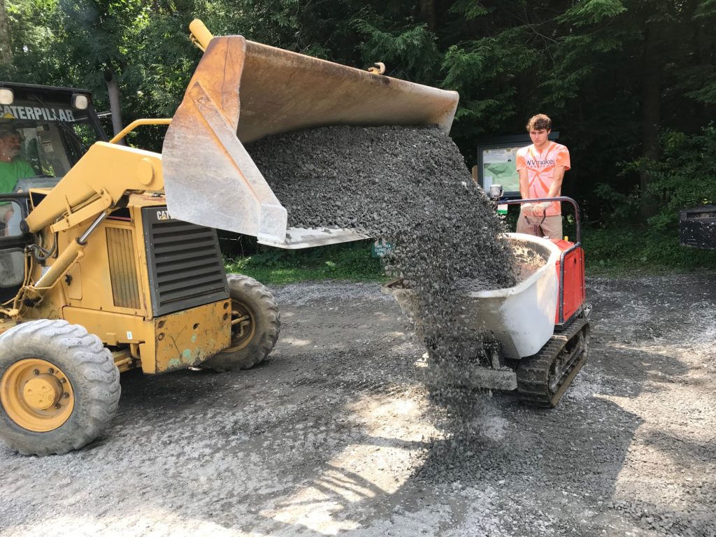
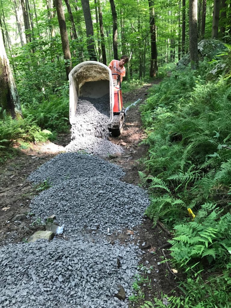
The time had come to switch to machines to move the gravel to the lower half of the project, and we did. We ended up using two stand-behind motorized concrete buggies, made for transporting concrete into hard-to-reach corners of construction sites. They can carry a payload of 1,000 pounds per trip, over rough terrain. A front-end loader filled up each of the two buggies at the gravel pile, they both carried gravel into the woods and down the trail, but they also helped us shape the trailbed with a pronounced crown as intended, because their tracks compressed the outer edges of the linear path-in-the-works but not the center spine, our intended crown.
The day that all the machinery, the workers, and the weather came together was a landmark day. We moved all the rest of the gravel in a day – somewhere round 30 tons. Those concrete buggies were the ticket, I’m tellin’ you what! I’m a convert. In one big day, we got over the hump and got all the stone laid upon the trailbed, not to mention finally clearing up Reservoir Parking Lot of all gravel piles and restoring its full parking capacity.
That didn’t mean that the job was over, however. Rakes and tampers were used to shape and tamp the pronounced crown, and, as usual, a keen eye was peeled to always improve the drainage situation. Over a handful of further work sessions–
*all water was captured and steered off of the trail, and
*all dips, drainage ditches and waterbars were carefully shaped to capture and carry water AND to also be very ride-able and ski-able.
Then, one day, I realized that all the gravel had been placed and shaped, the entire width of the old roadbed had been converted into useable trailbed for all the legal uses, and that all the surface water and groundwater had been accounted for. Our task was done!
Since then, I have had a chance to walk it, mountain bike it, and cross-country ski it, in both directions. All that’s left is for me to run it. I’m happy to say that it met my expectations. It’s ‘intermediate’ in difficulty for all these things, with the wider sections offering fun options harder than the ‘easy lane.’
It has taken you longer to read this description of the work than it does to actually hike the trail segment! I hope you agree with me that we succeeded in rectifying the problems on ‘Campground Hill’ in a unique and appropriate way – side-by-side options of different difficulty levels — that you probably have not seen on trails elsewhere. Every trail situation is at least a bit unique, and this ‘new rock on top of old’ one is an anomaly in the Coopers Rock State Forest context. May this work of stone on stone outlast us all.